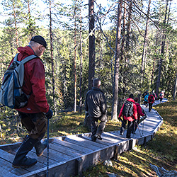
Hossa National Park Trails

There are about 90 km of trails in the Hossa National Park. The trails, most of which are easy to travel on, run through the most handsome esker and lake scenery in Hossa. You can set off for a long hike by linking circle trails by means of the connecting trails. There are trails, destinations and accommodation that are accessible to all in the national park and close to the visitor centre.
In many places, the hiking and biking trails run along the same trails. Please note, that in summer, cycling is permitted only on four mountain biking routes. Hossa also provides trails that are accessible to all. Please be considerate to the others on the trail.
There is no winter maintenance on the hiking or biking trails.
Easy Trails
Lihapyörre Trail, Accessible, 200 m each way

Available when the ground is unfrozen. No winter maintenance.
Travel time (there and back) less than 30 minutes.
Category:  an easy wheelchair trail
Starting point: Lihapyörre parking area
Description of the Lihapyörre Accessible Trail
Huosilampi Trail, Accessible, 500 m each way

Available when the ground is unfrozen. No winter maintenance.
Travel time (there and back) less than 1 h
Category:  a demanding wheelchair trail
Starting point: the parking area opposite to the Lihapyörre parking area
Description of the Huosilampi Accessible Trail
Muikkupuron mutka Trail, Accessible, 1.5 km each way

Available when the ground is unfrozen. No winter maintenance.
Travel time about 1 h by wheelchair / each way, on foot 0,5 h.
Category:  a demanding wheelchair trail
  easy
easy
Starting point: Hossalaislammet parking area
Description of the Muikkupuron mutka Accessible Trail
Hossa Nature Trail, 3 km, Circle Trail

Available when the ground is unfrozen. No winter maintenance.
Travel time about 1 h
Category  easy -
  intermediate
Starting point: visitor centre
Description of the Hossa Nature Trail
Hakokosken hujaus Trail, 5 km, Circle Trail

Available when the ground is unfrozen. No winter maintenance.
travel time about 2 hrs
Category:  easy -
  intermediate
Starting point: Huosivirta parking area
Description of the Hakokosken hujaus Trail
Other Hiking Trails
Huosiuksen huikonen Trail, 8 km, Circle Trail

Available when the ground is unfrozen. No winter maintenance.
travel time about 3‒4 hrs
Category:  intermediate
Starting point: Huosivirta parking area
Description of the Huosiuksen huikonen Trail
Värikallion kaarros Trail, 8 km, Circle Trail

Available when the ground is unfrozen. No winter maintenance.
travel time about 3 hrs
Category:  intermediate-demanding
Starting point: Lihapyörre
Description of the Värikallion kaarros Trail
Laukkujärven lenkki Trail, 10 km, Circle Trail

Available when the ground is unfrozen. No winter maintenance.
travel time about 3 hrs
Category:  intermediate
Starting point: Hossalaislammet
Description of the Laukkujärven lenkki Trail
Kokalmuksen kierros Trail, 14 km, Circle Trail

Available when the ground is unfrozen. No winter maintenance.
travel time about 4‒5 hrs
Category:  easy
easy
Starting point: Hossalaislammet
Description of the Kokalmuksen kierros Trail
Ölökyn ylitys Trail, 5 km, Circle Trail

Available when the ground is unfrozen. No winter maintenance.
travel time about 3 hrs
Category:  demanding
Starting point: Julma-Ölkky parking area
Description of the Ölökyn ylitys Trail
Ölökyn ähkäsy Trail, 10 km, Circle Trail

Available when the ground is unfrozen. No winter maintenance.
travel time about 5 hrs
Category:  demanding
Starting point: Julma-Ölkky parking area
Description of the Ölökyn ähkäsy Trail
Mountain Biking Trails
Jatkon valkea Trail, 10 km, Partly a Circle Trail

Available when the ground is unfrozen. No winter maintenance.
travel time about 1 h 10 min
Category:  easy
easy
Starting point: visitor centre, the starting point for mountain biking trails
Description of the Jatkon valkea Trail
Harjujen huikonen Trail, 12.5 km, Circle Trail

Available when the ground is unfrozen. No winter maintenance.
travel time about 1.5 h
Category:  partly demanding / intermediate
Starting point: visitor centre, the starting point for mountain biking trails
Description of the Harjujen huikonen Trail
Kokalmuksen kierros Trail, 14 km, Circle Trail

Available when the ground is unfrozen. No winter maintenance.
travel time about 1.5 h
Category:  partly demanding
Starting point: Hossalaislammet parking area
Description of the Kokalmuksen kierros Trail
Sininen saavutus Trail, 50 km, Circle Trail

Available when the ground is unfrozen. No winter maintenance.
travel time about 4.5 h
Category:  demanding
Starting point: visitor centre, the starting point for mountain biking trails
Description of the Sininen saavutus Trail
Canoeing Trails
Iijärvi Canoeing Route, 14 km

Available when the ground is unfrozen.
travel time about 8 hours
Category: rapids scale II, a demanding route
Starting point: Iijärvi
Description of the Iijärvi Canoeing Route
Somero Canoeing Route, 16 km

Available when the ground is unfrozen.
travel time about 14 hours
Category: rapids scale I-II, an easy route
Starting point: lake Julma-Ölkky
Description of the Somero Canoeing Route
Peranka Canoeing Route, 37 km

Available when the ground is unfrozen.
travel time about 2-3 days
Category: rapids scale I-II+
Starting point: Lake Iso-Perankajärvi
Description of the Peranka Canoeing Route
Hossanjoki Canoeing Route 40 km

Available when the ground is unfrozen.
travel time about 2-3 days
Category: rapids scale I-II+
Starting point: Lake Hossanjärvi
Description of the Hossanjoki Canoeing Route
Winter trails
There is approximately over 30 kilometres cross-country skiing trails in Hossa area. The skiing trails are meant for classic style skiing. Wilderness tracks and multipurpose tracks are suitable for skiing, fatbiking, snow-shoeing and walking. The trails are maintained when there is enough of snow and ice. The wilderness tracks are maintained in January - April.
- Check the latest maintenance https://suomussalmi.fluentprogress.fi/outdoors.
- Map of winter trails in Hossa (pdf, 1,1 Mb, julkaisut.metsa.fi). Please note, there may be temporary changes in Seipiniemi trails due to timber harvesting.
You can also move along the drifts of untouched snow. In spring, the period of crusty snow provides many opportunities for exercising. You can also go skiing, snowshoeing or fatbiking along the maintenance tracks.
Other Maps


